


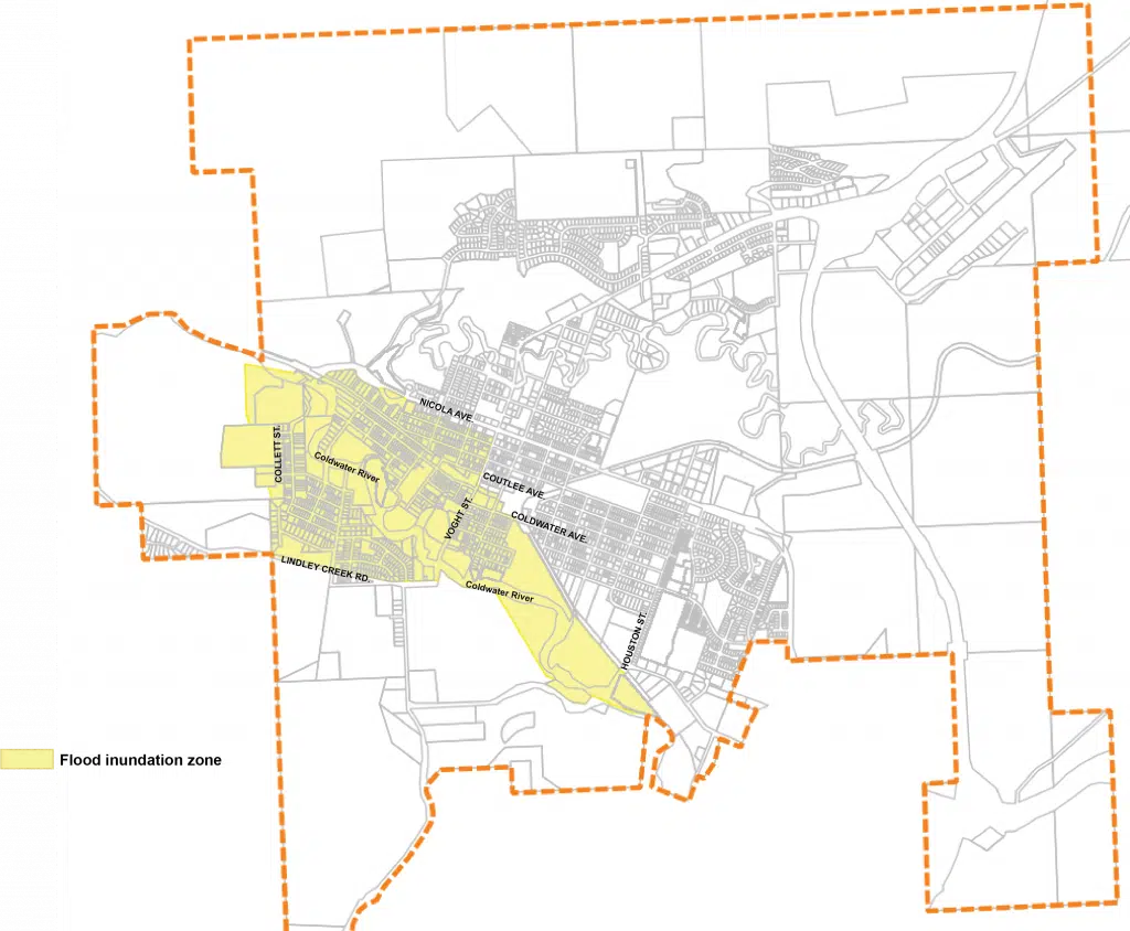
The Flood Inundation Zone in the City of Merritt. (Photo via City of Merritt)
With heavy rain in the forecast for much of coastal B.C. for the next few days, the City of Merritt will be monitoring the situation locally, just in case.
“Right now, we are looking at an expected volume flow [in the Coldwater River] of about 130 cubic metres per second,” Merritt CAO Sean Smith said Wednesday afternoon.
“We don’t know exactly what the last event was given most of the stations were taken out of order throughout the process, but the flows for that were estimated to be somewhere between 300 and 600 cubic metres per second, and so 130 is still a very significant event.”
If the Coldwater River does flow at 130 cubic metres per second, it would be more than double the peak seen during this year’s spring snowmelt.
Speaking this afternoon, Public Safety Minister Mike Farnworth said the province is bracing for “three big pulses of storms with increasing intensity” over the next week.
“The one we’re seeing now, another over the weekend, and the biggest hitting around Tuesday,” he said. “We’re redoubling our efforts to not only recover from the incredible destruction from last week’s events, but to prepare and respond to the significant weather lining up through the next week.
“I urge all British Columbians to be extremely vigilant. Keep a close eye on weather alerts to your area.”
As part of these storm systems, some forecasters have been predicting as much as 115 mm of rain in Hope by Sunday night, compared to just 13 mm in Merritt.
“Where we don’t know exactly what the weather is going to look like, our preparations are really are on our dike assessments and then bringing in any emergency work that is necessary though it doesn’t look at this time to be nearly so significant as our last atmospheric river event,” Smith added.
Still, there are some concerns about runoff in the Merritt area due to soil saturation caused by floods and fires this year, as well as melting snow at higher elevations.
“Our concern on this is that with the massive flood we had, did that damage our dikes? Did it alter the Coldwater’s capacity to carry that much water?” Merritt Emergency Information Officer, Greg Lowis told NL News.
“Everywhere in the City that the Coldwater River runs through remains on an evacuation order at this time. Whether or not we wind up getting a worrying amount of water, then I’m sure we’ll have some plans in place.”
The City of Merritt has released a map online showing the flood inundation zone, which is spread out around the southern and western part of Merritt. People with properties in the area are being told to contact the City of Merritt for a damage assessment, if they haven’t already done so.
“If you are a homeowner and have already contacted the City of Merritt to receive an update on your Rapid Damage assessment, you can expect a call back from City Building Official,” a City of Merritt statement said.
People who own properties that were given red placards are being “actively” contacted, officials say.
More Merrittonians will be allowed to return home on Saturday, Nov. 27, when Phase 2 of the City’s return home plan is expected to kick in.
A virtual information session for all Merritt residents is being held at 3 p.m. that day. Details about that session can be found here.


