


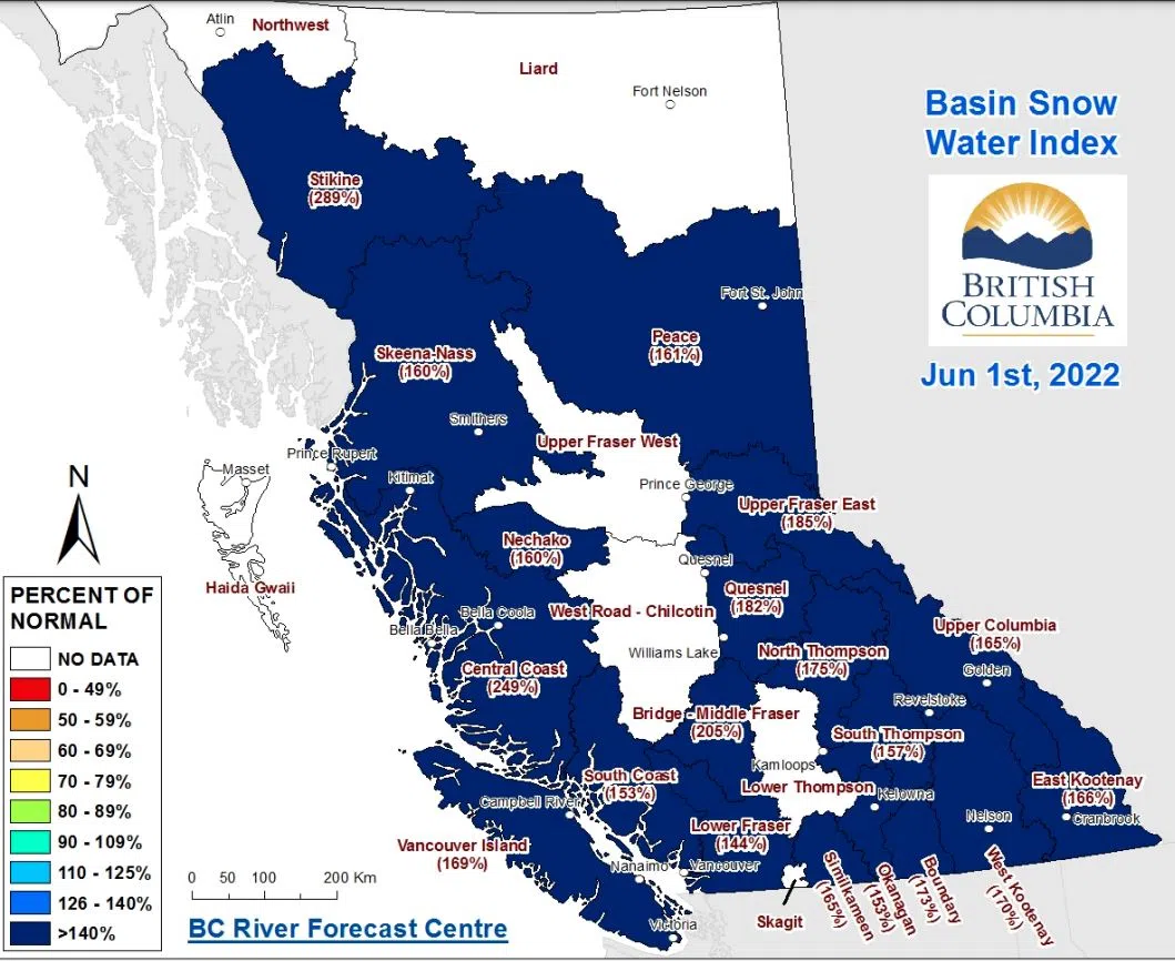
A substantial increase to the snowpack levels in the North and South Thompson river basins, when you compare it to the seasonal average for this time of year.
New data from the BC River Forecast Centre released Wednesday shows the North Thompson at 175 per cent of normal, up from 142 per cent back on May 15.
Similarly, the South Thompson snowpack saw an increase from 113 per cent to 157 per cent as of June 1.
“Based on the June 1 Snow Basin Indices, above normal snow pack exists for all regions of the province. This indicates a continued significant risk for high freshet flows, especially if adverse weather occurs.” the River Forecast Centre said.
“Regions that remain at relatively high risk due to snow pack, but are not exclusive to, include the Upper Fraser, Cariboo Mountains, North Thompson, South Thompson, Lower Fraser, Upper Columbia, the Kootenays, Similkameen, and the northern regions of the province.
“Other Interior regions like the Okanagan, Nicola and Peace remain at risk to extreme rainfall events,” the statement added.
These increases were not unexpected as cooler, wetter weather has slowed the melting of snow this season. As of June 1 last year, the North Thompson snowpack was at 98 per cent of normal while the South Thompson was at 69 per cent.
“It is important for everyone to know that everything is compared to seasonal average,” Greg Wightman, the Utility Services Manager with the City of Kamloops said Tuesday.
“Typically this time of year there is very little or no snow and when we’re looking at year like we have currently where there is snow, those numbers that percentage is very skewed.”
The River Forecast Centre says a snowpack level of 130 per cent is considered to be well above the normal.
A high streamflow advisory is in place for the North Thompson River and its tributaries around Barriere and Clearwater.
For the latest on flood watches, warnings, and streamflow advisories, go here.
More to come


