


photo via Paul James
The Kamloops area, including the Shuswap, has been given a reprieve from the dry conditions due to varying amounts of rain through Tuesday.
While the official reading at the Kamloops Airport only says half-a-millimeter fell yesterday, other areas saw much more precipitation.
The system has also significantly increased the air-quality in the region.
However, a Special Air Quality statement from Environment Canada does remain in-effect for Kamloops, as smoke from the fires is forecast to return later this evening — unless additional rain today keeps the smoke down.
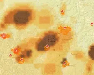
Smoke forecast for midnight on August 24th/via firesmoke.ca
The BC Wildfire Service is reporting at least 2 to 3-millimeters likely fell over the Bush Creek East fire through Tuesday, with some parts likely seeing even more rain.
It remains unclear as to what impact this may have had on the fire itself, though the Service says it expects fire intensity to ease, as temperatures in the area are expected to remain below 20-degrees today.
No new evacuation orders have been issued, and the BC Wildfire Service says much of its operational challenges on the Bush Creek East fire have not changed.
It is cautioning those who remain in the area to watch for falling trees.
“Winds and rain have the potential to cause danger trees to fall,” notes the Wildfire Service in its update at 10pm on Tuesday. “People in the area should exercise extreme caution under the forecast conditions. Several major safety hazards are present in the area.”
It also notes the scope of the fire remains a challenge to determine.
“Due to poor visibility, an accurate updated perimeter track is not currently able to be obtained through geographic mapping,” noted the Service. “The latest perimeter has been obtained from thermal scanning and the data may be skewed by radiant heat. Once visibility improves, an accurate perimeter will be mapped and the perimeter will be updated on the BC Wildfire Service map.”
The Bush Creek East fire is currently listed as some 410-square kilometers in size.
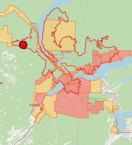
Map of the Bush Creek East fire/via BC Wildfire Service


