


A new, long-term strategy to help Kamloops “beat the heat” has been unveiled at City Hall.
The new heat response plan includes 9 separate action points, mostly based around developing more tree canopy areas through the major corridors and active transportation routes so people can find relief, as well as reduce the ambient heat that comes from exposed pavement.
The plan would also include the potential of getting home owners and developers to buy into the concept.
“Toronto, Ontario, is using economic incentives to encourage developers to build light-coloured and vegetated roofs that reduce the urban heat island effect,” noted a report put together by Urban Systems. “Another subsidy program in Toronto incentivizes landowners to plant more trees on private land.”
Report author Alison Rustand has told Kamloops council the current strategy of opening a centralized cooling center — such as the City has been doing with the Sandman Center — doesn’t work well in practice.
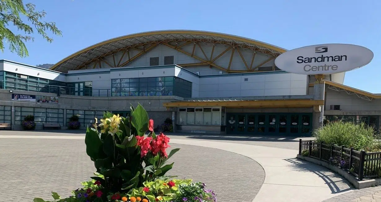
Public entrance to the Sandman Center in downtown Kamloops, which has previously been used as a cooling center during heat protocols/via Victor Kaisar
“During the heat dome, it would actually just be dangerous just to get to the cooling center, even if you’re in your car,” she noted. “Thinking about somebody who takes the bus, they’d have to get off on Seymour, walk all the way down to the Sandman. By then, honestly, that’s dangerous.”
The City also notes that during past heat events, only about 20 people would utilize the Sandman Center — on average — every day.
“There’s some interested in maybe doing a bit of a transition here. You’re still using a central cooling center, but maybe starting to transition into also maybe having different centers,” noted Rustand in her presentation to council. “That really comes from the idea of people not necessarily having the time, or wanting to stay in one place for very long.”
She says a concept being utilized in other cities, including Toronto, is the establishment of a so-called Heat Relief Network throughout the city, rather than open up a centralized cooling facility like the Sandman Center.
“You would have non-profits involved in it. You would have spaces that the City controls or owns, as well as outdoor spaces such as pools and splash pads,” said Rustand.
The City of Kamloops has already indicated its willingness to establish more community-based cooling locations, and has already been implementing the so-called Cool Spaces Program on hybrid basis this year, with full implementation expected in the summer of 2025.
According to the city, the plan includes:
• Unhoused populations are provided cooling spaces by social agencies with whom have pre-existing relationships.
• Existing outdoor and indoor cool spaces operated by the City are leveraged where hours can be extended and fees reduced or eliminated to minimize barriers to entry. The most important spaces are water parks and outdoor and indoor pools.
• The Kamloops Heat Relief Network of non-profit (e.g. social agencies, social clubs, faith-based organizations) and for-profit organizations (e.g. malls, grocery stores) is activated to provide varying levels of short-term relief to the general public by creating places of refuge with places to sit and bottles of water/fountains/filling stations in areas that already see high traffic or in areas where few cooling options exist.
• For-profit organizations’ cool spaces are marketed towards the general population, while social agencies’ cool spaces are targeted at unhoused individuals.
• The Kamloops Heat Relief Network is engaged strategically depending on the level of heat alert. For example, level 1 would activate the Core Network of organizations and level 2 would activate the Extended Network. Organizations could change their involvement from year to year, depending on the success of the option in the previous year or the availability of volunteers.
• The City plays a key role in convening groups, identifying roles from year to year and accessing resources to purchase water bottles and other required materials.
• Information about the network is maintained and updated annually on the existing interactive City of Kamloops map. General information and a few key locations in different neighbourhoods is included in print materials.
• Signage is provided to all participants in the form of a poster and/or sandwich board.
Meanwhile, the analysis done in the Urban Systems report also includes heat mapping of the city, which has indicated the North Shore has the highest level of heat vulnerability in Kamloops, mostly due to the older buildings in the community, as well as a lack of tree cover.
-
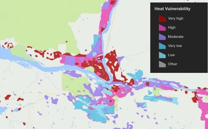
- Heat vulnerability map of Kamloops/via Urban Systems


