


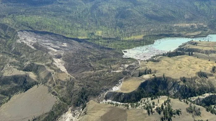
Aerial photo of Chilcotin slide zone/via Willie Sellars
In an updated forecast, the BC Government is lowering the risk level from the blockage of the Chilcotin River in the southern Cariboo.
“Updated modelling of the landslide across the Chilcotin River provides an improved assessment of worst-case scenario risks to people and communities from a sudden failure of the landslide structure and associated flooding,” said the BC government in a release on Saturday evening. “Expert modelling indicates that even in the worst-case scenario (a sudden failure of the natural dam), water levels in the Fraser River are anticipated to be below freshet (spring snowmelt) season levels. However, flows in the Chilcotin River are expected to be far above normal freshet flows, with potentially significant impacts on the local ecosystem and risks to public safety.”
The province also says a sudden breach is less likely than a slower release.
“There remain risks to public safety, including the potential of further landslides upstream of the natural dam and downstream once the water begins to flow through,” continued the BC government. “People are urged to keep out of the Chilcotin River valley between Hanceville and the confluence of Fraser River. An evacuation order by the Cariboo Regional District remains in place. People are also advised to stay away from the banks of the Fraser River.”
Emergency Management and Climate Readiness BC put out an alert after the Chilcotin River became blocked by a natural landside on Tuesday evening, creating a backflow of water some 11 kilometers long.
Expectations are the river, which saw similar slides in 2004 and 1964, will likely pass over the slide once the water reaches a certain level.
“It is still uncertain when and how the water pooling behind the dam will re-enter the Chilcotin River, but it could occur at any time,” said EMCR in its release. “The Province is actively monitoring the situation 24/7 and will continue to share the latest information with the public as it becomes available.”


