


Facebook via Rick Nickel
Update
Drive BC says that Highway 5 continues to be down to single lane alternating traffic as a result of flooding at Allan Creek Rec Site (36 km south of Valemount).
Drivers are advised to watch for traffic control and to expect delays. Drive BC says its next update will come at 10:00 AM Wednesday, June 4.
This update was provided at 10:16 AM Tuesday.
⚠️#BCHwy5 – single lane alternating traffic remains in effect at the Allan Creek Rec Site due to earlier flooding.
Watch for traffic control and expect delays.#Valemount
ℹ️https://t.co/Mn2z9SfNnH pic.twitter.com/e4TIGWIlzj— DriveBC (@DriveBC) June 3, 2025
Original
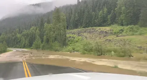
Drive BC is reporting that Highway 5 north of Blue River is dealing with continued flooding.
It says flooding at the Allan Creek Rec Site, about 35 km south of Valemount, has left the Yellowhead down to single lane, alternating traffic.
This has prompted a warning from DriveBC to expect delays travelling through the corridor, which is the main route for truck tourist traffic moving through Kamloops into the Jasper region, and beyond that to Edmonton.
Drive BC is expected to provide its next update on Highway 5 North at around 10:00 AM on Tuesday.
The highway started to become overwhelmed by fast-flowing streams in the area on Saturday, after warmer-than-normal temperatures leading into and through the weekend began to accelerate the snowpack melt.
⚠️👋REMINDER – #BCHwy5 is open to single lane alternating traffic near Chappell Creek Rec Site north of #BlueRiverBC. Expect delays. #YellowheadHwy #ThunderRiverBC #LempriereBC ℹ️For more info: https://t.co/71RogFuMjW
— DriveBC (@DriveBC) June 2, 2025
Video via Rick Nickel on Facebook
Temperatures last week, which hit 10 to 12 degrees above normal (24c), have also generated high-water flows along the North Thompson and Fraser Rivers.
The McLure and Little Fort Ferries crossing the North Thompson on either side of Barriere have been pulled out of service due the threat of debris and the increased water flows along the River, which is expected to start peaking later this week in the Clearwater area.
DriveBC says users of those ferry services should not expect an update for at least a week — June 9th.
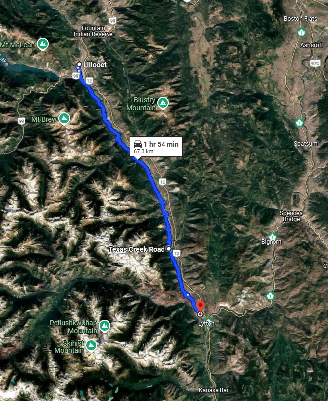
Overview of route west side of the Fraser in the Lytton area would have to navigate to cross out of the region by vehicle. A secondary vehicle route to a bridge near Boston Bar was rendered impassable following the 2021 atmospheric river event /via Google Maps
In the Fraser Canyon, efforts over the weekend by Yellowhead Road and Bridge (YRB Nicola) to keep the Lytton Ferry operational became futile on Sunday evening, with the operators forced to put a stop to crossings at that location.
While an annual event, the loss of the Lytton Ferry service means residents who live in communities to the west of the Fraser River in the Lytton area have limited options.
Locals who live on the west side of the Fraser – anticipating the annual disruption – establish their own vehicle connections at a parking lot across the CN train bridge.
That bridge does include a safe walking area.
However, should there be an immediate need to get people out of the area quickly — such as a fast-moving wildfire — the only other option for the roughly 250 residents who live there is to head north to Lillooet and cross over the Fraser River at Highway 99.
Until late 2021, residents did have a secondary egress route to the south.
While similar in distance to Lillooet, the route to the Cog Harrington Bridge was rendered inaccessible by the November, 2021 atmospheric river event.
It’s not clear when the Lytton Ferry will be back in service, though depending on the circumstances, the service can be sidelined for a week or more.


