


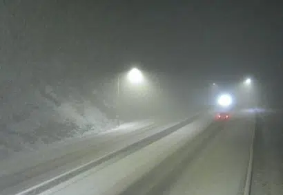
Coquihalla Summit northbound as of 6am, Tuesday, October 24/via DriveBC
The first taste of winter along the mountain passes is starting to take effect, with snow accumulating along the Coquihalla Summit and other higher elevations, including the Hope-Princeton route.
Environment Canada is predicting 5 to 10-centimeters along stretches of the Coquihalla through Tuesday, while 10 to 15-centimeters could be possible along Highway 3 through Manning Park.
Dave Duncan, GM of Yellowhead Road and Bridge — responsible for the Coquihalla — says drivers need to be prepared to drive for the conditions.
“The first storms of the year for drivers that have been going through a nice summer season is always a bit of a shock to the system,” noted Duncan. “So I would just really encourage everyone out there, that if you’re going to be out on the highway, have your equipment winter-ready. Have your [winter] tires on.”
Meanwhile, Environment Canada has now lifted its Special Weather Statement for the TransCanada through the Rockies, even though that region around Rogers Pass did see a sizeable snowfall overnight.
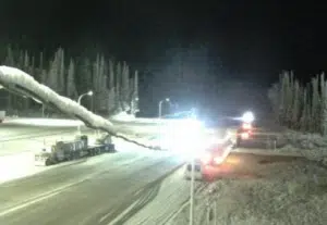
TransCanada Highway through Rogers Pass in the Rockies as of 4am, Tuesday, October 24th/via DriveBC
On the other side of the Rockies, western Alberta — including Calgary — is being hit with much larger doses of snow.
A winter snow advisory has been issued for the City of Calgary, with Environment Canada warning of up to 25 centimeters of heavy snow falling Tuesday.
Calgary officials say city crews are working around the clock to respond to the snow, and are applying material to help minimize icy buildup.
The city says additional contracted resources have been activated to help respond to the snow.
Environment Canada is warning people in Calgary and western Alberta to be prepared for quickly changing and deteriorating travel conditions.
–With files from the Canadian Press


